by Howard Rowson >>
1-2-2013 14:12:20
>>
1-2-2013 14:12:20 | |
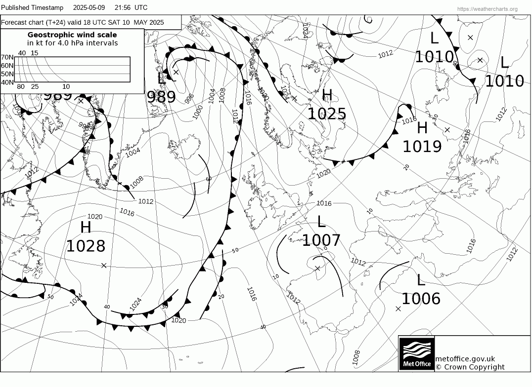
Ok , We have sufficient agreement from all the models for a West (Mon), West to WNW (Tue) for West Kirby. No breach of wall forecast, dawn2dusk speedsailing is on the cards.
Current anticipated flow 30-40kts for both days, kicking in through Monday morning, and sustained through Tuesday, with a gradual veer to WNW.
Temps. - Monday starting on the mild side (for Feb), cooling off through the day. Tuesday brrr.. cold , expect hail, sleet and snow, if any beefy showers were to hit. (likely)
|  |
|
by Howard Rowson
>>
1-2-2013 18:32:23 | |
Some doubt for Tuesday has crept into the 12z charts , Monday still good to go. Keeping an eye on the Ecm 12z update and updates thru this weekend.
| |
|
by Paul Burgess
>>
1-2-2013 19:11:15 | |
Anyone looking for somewhere to stay in west kirby when u come up to sail I can recommend http://www.numberfifteen.co.uk/ mention my name
|  |
|
by Howard Rowson
>>
2-2-2013 19:21:43 | |
Monday - Current 12z charts good for West 6 to 8 with gusts to 40+ , Tuesday has come back from the toilet rim, also looking good for 6 to 8 from the west, got to keep an eye on the weather front sinking south and its timing, may have the wind back a notch south of west
| |
|
by Howard Rowson
>>
3-2-2013 11:11:21 | |
I sense that for a change, rather than the usual downgrades we experience as a potential session draws nearer, this time we appear to be on an upgrade path.
The current Met Mslp charts for Monday are a sight for sore eyes, something the like we have not seen for an age, with an intense deep low pressure just to the se of iceland sinking se towards ne Scotland, tight isos country wide , deleivering the elusive westerly flow for WK.
Monday:
West 6 o 8 still very much on the cards for Monday, altough Wk is borderine for the West 7 to 9 just north of WK.
In real knots terms 30-40kts with gusts to 45 likely. West does look like being the flow angle, perhaps a notch broader. Although I have always said, it isnt a westerly until you are stood on the wall feeling it slap bang in your face.
Tuesday:
Still very much in the swathe of galefroce westerlies, howevver as mentioned yesterday we have an occlusion sinking south towards Wk. The Met have this on the radar, hence the wind backing a notch towards WSW. GFS model not picking this up in their current 00z wind stats ie. XC still dialing in a Westerly of some strength 6-8/9.
So in summary - green light for Monday, amber for Tuesday dependant upon the tming and orientation of the south sinking occlusion.
| |
|
by Ian Richards
>>
3-2-2013 13:15:38 | |
Meso not showing so much wind for tomorrow....? until 1800hrs
|  |
|
by Howard Rowson
>>
3-2-2013 16:01:03 | |
Don't worry Ian, West 6-8 with gusts to 50kts coastal forecast from the Beeb for Holyhead to Morecambe Bay - nerver wrong 
| |
|
by Howard Rowson
>>
4-2-2013 13:58:43 | |
Ok .. Tuesday ...?
The MetO have now issued a warning for severe gales from the west to wnw for Cornwall and Devon with gusts to 60-70mph.
For West Kirby .. tricky one, gale to severe gale westerly early on (before day break) backing wsw through the morning and easing to strong to gale, then veering west to wnw for the afternoon and back up to near gale to severe gale force .. cold with high wind chill and potential for snow / blizzards before day break. temps rising a tad for the afternoon, but the windchill still in place.
| |
|
by Howard Rowson
>>
4-2-2013 18:41:39 | |
Ok lets see where we are at for tomorrow.
The occluded front sweeping down from the north through Tuesday Morning looks like hitting WK just after noon, hold on to your hats , rigs, gear thereafter as the isos are tight on the northern side of the occlusion. The westerly should kick back in straight after with F7-F9, veering WNW probably at dusk, nw by mid evening.
Not the most reliable of forecasts when occlusions are dialed into the wind equation, but given the current stats I would expect tomorrow afternoon to run as forecast. (MetO)
| |
|
by Howard Rowson
>>
4-2-2013 18:47:16 | |
Based on the current MetO charts for 12 noon tomorrow I woulld expect an imminent issue of severe gales for northern irish sea waters
| |
|
by Howard Rowson
>>
5-2-2013 08:44:55 | |
Wind peeking this morning F6-F8 from the west to wnw, easing late morning and backing west/wbs then veering west after lunch building again to F7-F8, F9 at times, may veer full wnw before dark hits, veering nw early-mid evening. colder than yesterday, temps recovering mid afternoon to yesterdays values.
Yesterdays wind forecast no quite materialising as the flow had a touch of south in it (wbs) at times, only a true west clears north wales coast for a free flow in off the irish sea, anything interrupted by north wales will be gusty and forecast wind values not realised.
Nonetheless some great speeds posted yesterday and a credit to all who got out and gave it their best!
| |
|
by Michael George
>>
5-2-2013 08:47:24 | |
I guess most people didnt find the conditions ideal but hey... it was 10 times better than working!
I reckon there were more than 11 speedies out yesterday. A few posts missing perhaps? ;)
|  |
|
by Howard Rowson
>>
5-2-2013 14:32:40 | |
Hi Mike, fair play to you all, made my day. It's a very fine line between a perfect westerly forecast and what actually transpires, an ounce of south in the actual wind and conditions are downgraded from a true westerly session.
Currently tracking the occlusion in from the north west, wind has backed wsw as forecast and eased. Looks like the timimg of the occlusion has been put back an hour or so. Watching Hilbre for the veer to west and the "kick in"
| |