by Howard Rowson >>
4-11-2013 18:34:49
>>
4-11-2013 18:34:49 | |
We still have an anomaly between MetO and NAE wind data for WK tomorrow.
MetO seeing the Westerly kick in around 0900, NAE deferring the veer until noon and a tad broader than WNW, backing to WbN during the early afternoon
At the end of the day though Wk probably not sailable until early afternoon once the HT retreats off the wall.
20-30kts from the West to WNW should be the afternoon's flow, gust data may see 30-35kts with the potential for a 25kt mean average.
|  |
|
by Howard Rowson
>>
4-11-2013 18:44:02 | |
Looking a little further ahead ...potential for strong winds for the south coast Saturday from the Ssw / Sw , before high pressure ridges over the UK for Sunday, more than likely a temporary or brief settled spell prior to the atlantic reasserting itself to the north of the UK thereafter.
| |
|
by Howard Rowson
>>
5-11-2013 07:43:42 | |
Ok .. despite the failed forecast for WK Sunday, we must continue to run with that forecast. So today sees another opportunity to get out at WK before the big breeze hits (don't quote me on that  ). The forecast has marginally improved over yesterdays 12z outputs, with the Met finally aligning with the NAE data, with the wind kicking in from the .west to wnw around noon, perhaps coinciding with the retreat of the high tide. Potential for 6-8 from the wbn-wnw early afternoon, easing 5-7 as the afternoon progresses and backing west. Sunday was always a difficult call with low pressure tracking across the UK the net wind after the passage of the system overhead and the its direction always the hardest setup for the models to predict. ). The forecast has marginally improved over yesterdays 12z outputs, with the Met finally aligning with the NAE data, with the wind kicking in from the .west to wnw around noon, perhaps coinciding with the retreat of the high tide. Potential for 6-8 from the wbn-wnw early afternoon, easing 5-7 as the afternoon progresses and backing west. Sunday was always a difficult call with low pressure tracking across the UK the net wind after the passage of the system overhead and the its direction always the hardest setup for the models to predict.
| |
|
by Howard Rowson
>>
6-11-2013 08:06:21 | |
I was scratching my head yesterday morning as to why the Beeb coastal foecast had the wind for Holyhead to Morecambe Bay at F2-F7 for yestrday afternoon, 2 to 7 really? nah .... lol Beeb pretty much got it spot on, correctly predicting the wind around liverpool bay despite the Meto for WK being circa 27-40+ mph. The occluded front messed up the flow big time for WK with the wind not really kicking in til' mid to late arvo and possibly too broad. Another forecast to place in the trash bin... Atlantic still look pretty mobile out to the forecasst horizon with no sign of any hp blocks digging in, so expect wind over the next week or two from time to time
| |
|
by Howard Rowson
>>
8-11-2013 12:51:47 | |
Current model outputs for next week from the ECNWF, UKMO and GFS not really giving too much away at present, flip flopping between LP driven weather ot HP driven weather. ECM and UMMO favouring the LP setup especially towards the back end of the week Thursday to Sartuday. The GFS again a little quick out of the blocks with LP setup Tues / Wed now replaced with a predominantly HP setup until the later stages of the model run where again LP setup re-establishes itself for the UK. Nonetheless all three models showing a typical autumn pattern (zonal) with storms continuing to track east to the north of Scotland interspersed with brief ridging of the azores high towards the UK, which leads to a high degree of mobility to our weather pattern with less chance of HP blocks establishing themselves to our west (cold northerlies), east (mildish se/southerlies , or north (bitter ne/easterrlies). High pressure rooted to our south/sw leads to mild Sw'er coupled with the cooler veer to west.
| |
|
by Howard Rowson
>>
22-11-2013 19:21:47 | |
After 3 WK near misses with the westerly gale veering NW around or just after day break, the next opportunity shows its face towards the back end of next week, with the azores high slipping back to the sw of the uk alllowing a polar maritme incursion from the nw... GFS Friday , ECMWF Saturday , reasonable agreemement from the 3 models for the synoptics to pan out well for a west to wnw, with a deep low slipping se towards northern Scotland.
| |
|
by Ian Richards
>>
23-11-2013 19:40:17 | |
Gone!!
|  |
|
by Ian Richards
>>
23-11-2013 19:40:56 | |
Again!!
| |
|
by Howard Rowson
>>
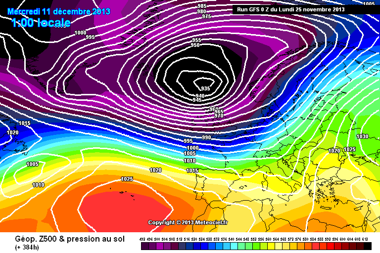
25-11-2013 07:56:53 | |
lol ... here's another one for you Ian .. a little early morning eye candy .... GFS going off on one ... unlikely to verify, Thats' 935MB just to the north of Scotland!!
| |
|
by Howard Rowson
>>
27-11-2013 13:34:23 | |
Potential for a west to wnw flow Friday, in particular first light to noon, thereafter the chance of broadening to a too broad NW'ly increases.
Crica F6-F7 potentially F6-F8
High tide around dawn @ 7.8m sub breach level.
| |
|
by Howard Rowson
>>
28-11-2013 18:45:54 | |
Yes Ian AGAIN only a small window of opportunity for a WNW flow before the NW pumps in 6 to 8. First light to mid morning is the potential window for sailable conditions, even this open to debate as the forecast "WNW" flow may be too broad. NAE has it bang on WNW at 0900hrs, NW'ly at 1200hrs. The Met forecast a back to WNW for the afternoon .. humm unlikely.
| |
|
by Howard Rowson
>>
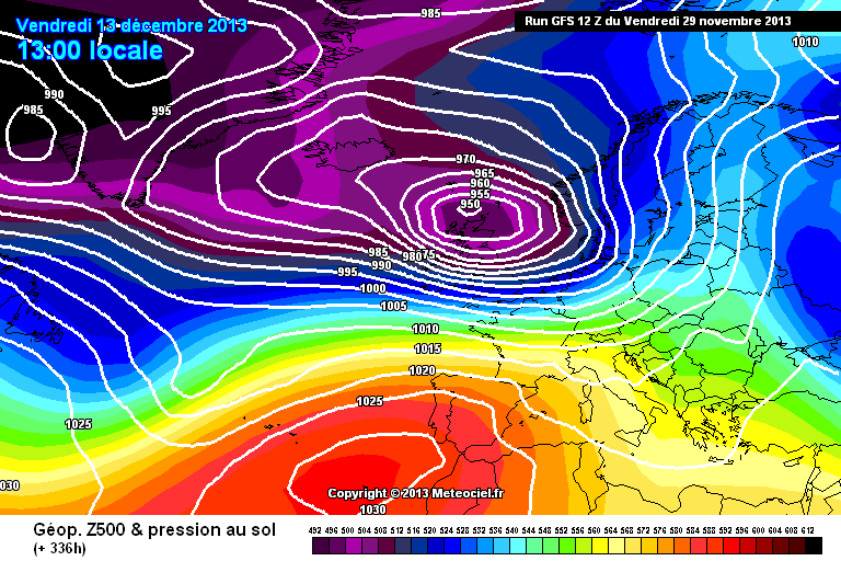
29-11-2013 18:08:44 | |
The return of the beast
| |