by Mark Matthews >>
31-8-2013 06:00:25
>>
31-8-2013 06:00:25 | |
| Ok Howie we have had an incredible summer, and it doesn't seem like its going to end?
But is there any chance you could at least pull the dust sheets off the wind machine and get it ticking over and ready?
Cheers mate laters...... |  |
|
by Ian Richards
>>
31-8-2013 07:47:39 | |
| Next year Karpathos, they got wind. |  |
by Tim Otte >>
31-8-2013 16:24:37
>>
31-8-2013 16:24:37 | |
| Yes, we got a lot of wind in Karpathos this summer, as usual and as every year!!
If you need any advise please feel free to contact me.
|  |
|
by Howard Rowson
>>
31-8-2013 19:59:13 | |
 ahh the old wind machine ...hmmm .... just spent the summer overhauling it pal..... last year it was a tad intermittemt with the wind delivery system, especially anything from the west to wnw. The upgraded system should be good to roll this autumn, if not .. I guess we'll all have to gate crash Namibia ... ahh the old wind machine ...hmmm .... just spent the summer overhauling it pal..... last year it was a tad intermittemt with the wind delivery system, especially anything from the west to wnw. The upgraded system should be good to roll this autumn, if not .. I guess we'll all have to gate crash Namibia ... for the once a year session.. for the once a year session..
|  |
|
by Ian Richards
>>
3-9-2013 07:49:09 | |
There may be no wind but the sun is shining, I'm saving a fortune on diesel and cycling with Strava is a great light wind option.
Wil we get any wind in September?
| |
|
by Howard Rowson
>>
3-9-2013 17:45:08 | |
Either NOAA have totally screwed up the atlantic hurricane season forecast or we are in for some major winds between september and november .http://www.noaanews.noaa.gov/stories2013/20130808_atlantichurricaneupdate.html so far this season (started in june) has been exceptionally quiet. with very little activity to speak of.... Ian the diesel money pot may well come in handy, if the uk fails to deliver you'll have namibia sorted ..
| |
|
by Howard Rowson
>>
4-9-2013 07:01:38 | |
Both ECMWF and GFS @ T+240hrs showing signs of tropical storm activity brewing to the south of the Azores High (AZH), heading west - wnw towards the eastern seaboard of the USA then on a recurve towards Iceland / UK (northeast atlantic) GFS T+384hrs... the chance of charts @ T+240 verifying are on par with me getting on the water this year ...
| |
|
by Ian Richards
>>
6-9-2013 20:04:01 | |
Still no end in sight of this wind drought, even a 7.8 day would be nice.
| |
|
by Howard Rowson
>>
9-9-2013 12:30:02 | |
The atlantic is looking rather lively early next week with a deep area of low pressure tracking west > east to the north of scotland with the potential for secondary southern flank inswingers ...
| |
|
by Howard Rowson
>>
9-9-2013 12:37:51 | |
GFS ramping things up rather nicely ... will it verify .. maybe .. as the ECMWF and MetO are running with the same theme.
| |
|
by Howard Rowson
>>
9-9-2013 12:39:50 | |
Iceland looking .. err .. . windy!
| |
|
by Matthew York
>>
9-9-2013 13:55:35 | |
icelands a biit cold for me howie :) how it looking for kirby next week , was thinking of going east tomorrow to wells ?
|  |
|
by Howard Rowson
>>
9-9-2013 16:47:48 | |
Ok GFS 12z continuing with the ramped up west veering wnw flow for next Monday. Based on previous stormtracks that showed great promise @ 5-7 days only to slide in to the bog @ sub 3 days, a pinch of salt taken with this chart at present then, but a west to wnw F7-F9 would be a bonus early start to autumn.
MetO 12z chart comparison for Sunday .... promising then for verifying the GFS 12z monday chart.

| |
|
by Adam Gustafsson
>>
9-9-2013 17:20:35 | |
That Chart is a Whole week away!!!!!!!!!!!!!!!!!!!!!!!!!!!!!!!!!!!!!!!!!!!!!!!!!!!!!!!!!!!!!!!!!!!!!!!!!!!!!!!!!!!!!!!!!!!!!!!!!!!!!!!!!!!!!!!!!!!!!!!!!!!!!!!!!!!!!!!!
Looks nice though!!!!!!!!!!!!!!!!!!!
|  |
|
by Howard Rowson
>>
9-9-2013 17:30:01 | |
Lol hey Adam, good to see you are keeping me in check Nice eye candy indeed, we'll see what the ecmwf dishes up on it's 12z outputs, anything close to the GFS and confidence is a little higher. It was n't that long ago when Si was running the UK USMs that 5 days out was a reasonably reliable time frame. Pants reliability over the past year or so .. sub 24hrs !
| |
|
by Howard Rowson
>>
9-9-2013 17:34:46 | |
It almost warrants a September stormtrack, I'll hold fire though .. see how the forecast develops over the next 24-48hrs.
| |
|
by Howard Rowson
>>
9-9-2013 17:39:04 | |
Xc (gfs data) has Wk firing 7-9 w to wnw for Monday .... one thing for sure the GFS does tend to over amplify short waves (depressions) at this range ie. 7 days
| |
|
by Howard Rowson
>>
9-9-2013 17:50:33 | |
Just to maintain the balance of forecast data, the NAvGem (x NOGaps) has a the storm way off to the NE of Scotland with only a mod 2 fresh westerly.

| |
|
by Howard Rowson
>>
9-9-2013 18:19:53 | |
A little more extreme and a faster transit through from the GEM output ... isos @ F10+ for northern Holland, Germany and Poland 

| |
|
by Mark Hayford
>>
9-9-2013 18:36:01 | |
Is that purple I see on next weeks windguru forecast or have I drunk to much meths??
|  |
|
by Howard Rowson
>>
9-9-2013 18:38:56 | |
And there we have it .. no verification from the ecmwf 12z of the GFS deep in bound low pressure. Nonetheless this may well be an outlier of the ecmwf ensemble, as this chart does not tie in with the Met's autumnal windy forecast for early next week.

| |
|
by Howard Rowson
>>
9-9-2013 18:43:19 | |
It is Mark, but more than likely somewhat over amplfied, I would n;t be dusting off the sub 5m just yet mate, the outcome at present remains to be seen, more than likely somewhere between the GFS and ECMWF. I would n't be suprised if tomorrows ECWMF 00z run has the low back down to the NE of Scotland with tight isos country wide.
| |
|
by John Roberts
>>
9-9-2013 21:09:11 | |
Mark,
Could you mail me at ayacata hot mail co uk? Forgot to ask you about booms last time out.
Cheers.
|  |
|
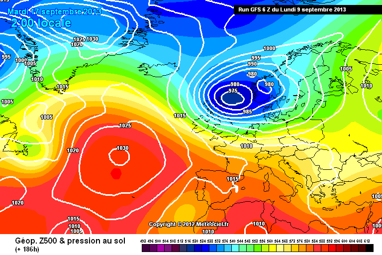
by Howard Rowson
>>
10-9-2013 06:49:22 | |
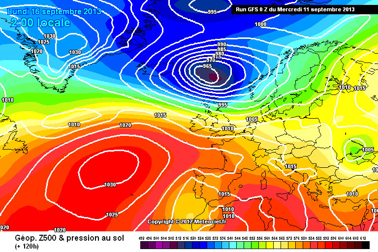
Ok .. this mornings 00z outputs from the big3 for early monday morning.
ECMWF
MetO

& GFS
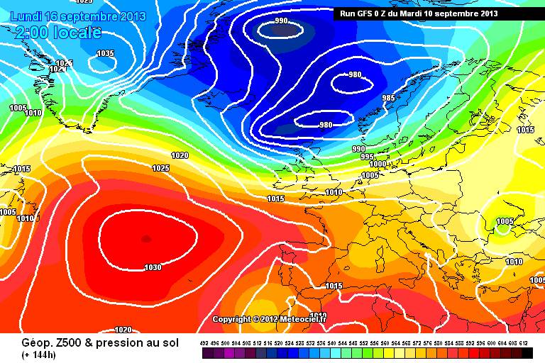
Improvements with the ecmwf from yesterdays 12z run with the lp closer to the UK and tighter feed of isos on the storms southern flank. UKMO bringing the storm in a little closer. GFS introducing a second lp centre close to the northwest of scotland .. interesting !
| |
|
by Howard Rowson
>>
10-9-2013 17:08:35 | |
Ok now for a round up of todays 12z outputs:
UKMO continuing with the theme of a deep low tracking se from Iceland Sunday into Monday. The Met have maintained this forecast over the past 48hrs, and backed up by its text forecast on the Met website for Sunday into Monday
UK Outlook for Sunday 15 Sep 2013 to Tuesday 24 Sep 2013:
Probably a dry start in the southeast on Sunday, but rain and strong winds across northwestern areas will soon push southeastwards through the day with much cooler air and blustery showers following, some heavy with local hail and thunder. The first half of next week has an autumnal and rather changeable look to it as cloudier periods with rain are interspersed by brighter periods with showers. Remaining windy, with the risk of severe gales in the north at first. Later next week and onwards for the rest of the forecast period looks like becoming a little less cold with temperatures returning to values nearer average for mid-September. Probably staying changeable though, with some fine weather but also some rain at times, this most likely wettest towards the north and west.
+120hr Sunday 1400hrs

+144hrs Monday 1400hrs

The GFS model however rather more variable with its storm track and depth, again no consistency over the past 48hrs
+120hrs Sunday 1400hrs
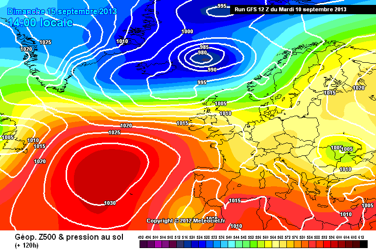
+144hrs Monday 1400hrs
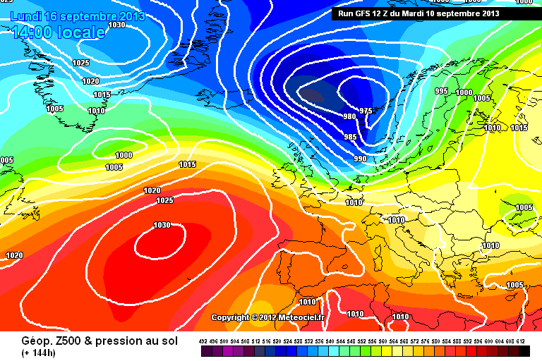
ECMWF 12z to follow
| |
|
by Howard Rowson
>>
10-9-2013 17:15:29 | |
Just on the off chance the above UKMO chart verifies for Monday, tides for WK are sub breach levels during daylight hours, the 8.6m may breach with a significant push in off the irish sea, but that is after 2100hrs
Shame Roa has a HT @ 9am Monday as gales and glass would be on the cards with a wsw early am.
| |
|
by Mark Hayford
>>
10-9-2013 23:59:39 | |
I know the forecast could change between now and Monday, but if we only get a forecast for speed board conditiond through night time, does any one fancy a night sail? Just a simple waterproof light to keep an eye on each other and avoid collisions (and a flask of coffe) required.
Been ages since WK has dished out a half decent speed session, so I'm happy to sail through the night if need be:)
| |
|
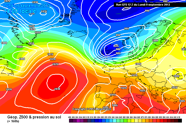
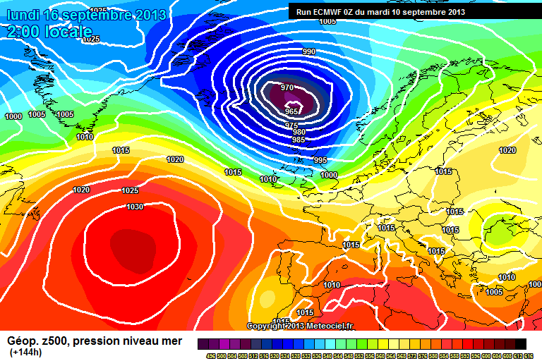
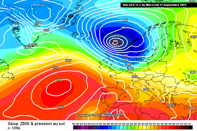
by Howard Rowson
>>
11-9-2013 07:07:36 | |
Lol .. keen mate!
Confidence at present is reasonably good for a sw veering wsw (sunday) veering west (sunday evening/night) maintaining a westerly through monday. All models pretty much in agreement with the mslp setup for the incoming storm this weekend with slight variations to the overall theme of windy. As the end of the week draws, we should start to see the likely outcome of timing, track and intensity, all key variables for delivery of a westerly during the day at WK.
ECMWF currently back on track after its' published outlier on Monday, and represents the best of the 3 at present with a sustained west to wnw flow through monday. UKMO currently indicating the storm's flow to peak during early monday, with a rather hasty retreat north eastwards of the storm during the day, with the flow moderating from circa F6-F9. The GFS model again running with a similar prognosis but dialing in additional caveats not shown on the ECM and UKMO models, and not quite delivering a setup for a monday gale.
ECM Monday +0200hrs
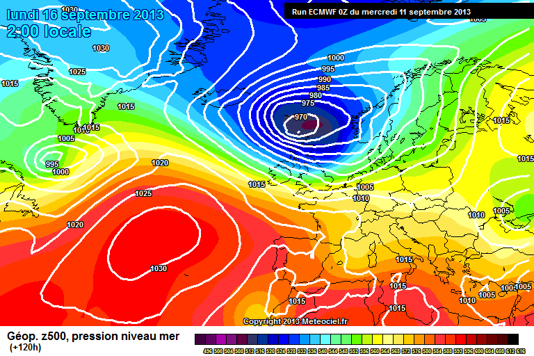
ECM Tuesday +0200hrs

UKMO Monday +0200hrs

GFS Monday +0200hrs
| |
|
by Ian Richards
>>
11-9-2013 07:08:40 | |
Mark,,, like the enthusiasm.
| |
|
by Howard Rowson
>>
11-9-2013 12:33:31 | |
The forecast for Monday progressing rather nicely, with the GFS model aligning closer to the ECMWF and UKMO models, as reflected with the wind stats from the likes of XC and Winguru. Still plenty of time left for adjustments and the mandatory downgrade at 3 days out .
A couple of potential issues to keep an eye on:
The UKMO model transitions the storm only as far south as FairIsle @ 965mb early monday then the storm is set to track north and fill slightly.
Impact: Best of the flow will be early Monday, moderating quite quickly through the day.
The GFS model indicating a secondary system out to the west of Ireland late Monday disrupting the westerly flow into Tuesday.
Impact:Timing of this feature, if it comes to pass will be critical in the maintaining of the west to wnw flow through daylight hours monday. Any advance in the timing of the secondary will disrupt play monday. Also evident on the ECMWF charts but delayed until late Tuesday into Wednesday.
NAVGEM model for 1400hrs Monday.
With the Jet Stream forecast to orientated from WNW, the NavGem charts isobars should be good for a westerly F7-F9. If the Jet was angled from the west or sw a wsw would be closwer to the net flow direction.... one to keep an eye on.

| |
|
by Howard Rowson
>>
11-9-2013 12:38:09 | |
MetOffice wind data for WK Sunday has the flow WSW before dark falls circa F6-F8 veering WNW around late evening F7-F9
| |
|
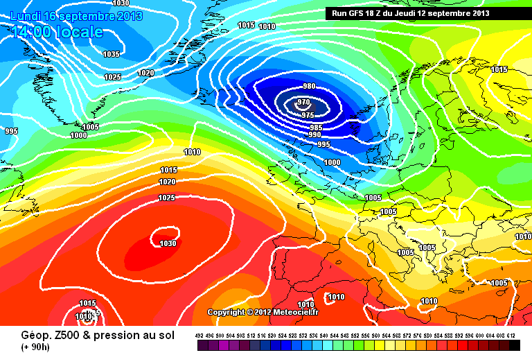
by Howard Rowson
>>
11-9-2013 17:17:48 | |
Interesting developments from the UKMO with their 12z update. Monday 1400hrs LP centre 975MB location NE Scotland - does n't get much better than that! I never like charts peaking with 5 days to go though. thats 5 days worth of potential downgrades 
Sometimes I scratch my head with the Met.. they issue the latest mslp chart indicating quite clearly a westerly gale, perhaps severe on west facing coasts from north wales northwards, yet their updated text forecast issued at 1600hrs now has the words severe gales removed and replaced with "winds will be strong" - ... ? does the left hand know what the right hand is doing?

The GFS equivalent not quite as impressive for 1400hrs monday perhaps closer to WNW and not as strong a flow, circa wnw F5-F8
| |
|
by Howard Rowson
>>
11-9-2013 17:22:40 | |
NAVGEM looking equally impressive albeit a touch tight am slowly veering west pm Solid F8, potential gusts to F10
If this session comes off crates of beer to Swags please

| |
|
by Howard Rowson
>>
11-9-2013 17:37:47 | |
One thing to note (forgot to take this into consideration with the wind flow estimation) The metociel charts have the Isobars are a 5mb intervals not the usual 4mb, therefore add about 1bft to the wind data thus far ie. solid F9 gusts to F11 ... lol
Tomorrow begins the countdown when mondays wind data appears on the Met forecasts, I am a little hesitant to start a stormtrack and potential heads up when Swags's topic "Fire it up!" is hooning along rather well...
If the ECM 12z chart is in keeping with the above, thats' a big step forward with this storm as full consensus (or thereabouts) from all three models sustained over 48hrs+
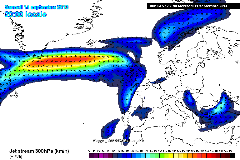
Impressive nonetheless is the fall in pressure from Saturday to Sunday with 1000mb bagged out depression to a 960MB raging F10 Bomb .. Jet Stream data shows why...and is primarily responsible for the rapid deepening of said storm, the faster the jet the more intensification is dialed into the storm.
| |
|
by Howard Rowson
>>
11-9-2013 17:52:48 | |
MetO wind data for WK Sunday evening (2200hrs) just raised the bar on the 1800hr update 31 gusting 53. Based on the 12z chart with iso tightness around midday monday I'll be taking bets soon on seeing 40 gusting 60+ tomorrow early morning for noon monday
| |
|
by Howard Rowson
>>
11-9-2013 18:51:55 | |
So goes it! ECMWF 12z hauling ass. as per the UKMO 12z epic run. now for 4 days worth of downgrades!

| |
|
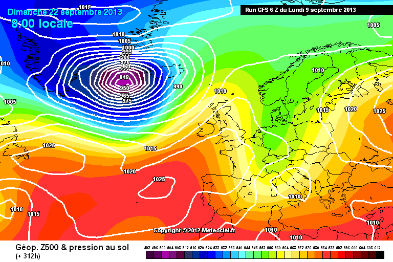
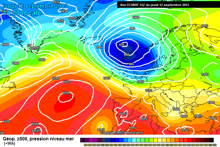
by Howard Rowson
>>
12-9-2013 06:57:49 | |
Ok we are still running with model consensus across the main 3, ECMWF, UKMO, and GFS with only slight variations between them.
We are now into the MetO 5 day forecast window, so have their wind stats to hand for tracking/monitoring. In addition the MetO marine extended outlook is now forecasting out to Mionday.
Track and intensity are the main areas of focus now, timing looks pretty spot on with the westerly window arriving Sunday evening through to Monday evening perhaps broadening to wnw later monday afternoon.
Current depth of storm circa 970mb perhaps down as low a 965mb. Current track Iceland-Saturday, Bailey-Sunday, FairIsle-Monday and perhaps Dogger Tuesday, although its ultimate final destination will not be clear until Saturday at the earliest in terms of track and depth, it may fill in the north sea, Tuesday.
I'll stay clear of wind stat predictions for now, but broadly speaking as we roll into monday Storm force winds are expected on the Sw flank of the system, with a swathe of severe gales down as far as northern england, with strong to gale force winds for southern england.
The latest mslp charts are the 00z run so don't really give a detailed picture of the setup for noon monday, todays 12z charts later this arvo for that.
Some early morning eye candy the NAVGEM for Monday 1400hrs - The Carlsberg chart!

| |
|
by Howard Rowson
>>
12-9-2013 11:37:46 | |
The MetO have now issued a severe wind warning for Sunday / Monday covering Scotland at present with the potential for gusts of 70mph+ but widely gusts of 50-60mph to be expected, with the peak of the strongest winds expected mid morning monday.The current wind data (MetO) for WK peaking around mid day pretty much translates as Westerly 6 to gale 8 with 7 to severe gale force 9 expected during the peak flow of the storm circa mid morning to early afternoon. It is anticipated that the flow will be west for the majority of the day perhaps a little broader later on, although the exact wind angle acheived on the day will be the last of the finer details to be established, probably Sunday.
| |
|
by Mark Hayford
>>
12-9-2013 14:01:05 | |
Nice one H:) Sunday evening session followed by a monday morning session. Will you be joining us?
| |
|
by John Roberts
>>
12-9-2013 18:24:53 | |
No, coz he sold me his speed board!
| |
|
by Matthew York
>>
12-9-2013 20:10:41 | |
howie if your coming i can lend you my moo 44
| |
|
by Mark Hayford
>>
12-9-2013 20:39:03 | |
Ha, H has a nice new MXR fin and a board to plug it in:)
| |
|
by Howard Rowson
>>
12-9-2013 22:27:31 | |
lol guys ... lets stick to speculating about the forecast ...
. I cannot believe R&J are 5 tomorrow ... where does the time go to? not been out since oct 11 seems like yesterday yet nearly 2 years ago now. Just picked up two MX16FS for their birthdays (raleigh mtb full suspension) so thats the speedboard pot empty again .any way where are we with the weather forecast
MetO wind data still has Wk firing from the west although lost a knot or two off the mean & gust peak, this is to be expected (post ramp downgrades) ..reckon the forecast wil settle somewhere around 30kts with gusts to 40. It'll feel more like winter with sub 10degc wind chill in the squally showers.
Some very odd outputs from the models for Tuesday - Friday, GFS leading the downgrades for Monday, UKMO doing a stall and fill to the north of Scotland Tuesday and hell knows what the ecmwf is up to end of the week after dropping into the north sea, paying our Belgium and Dutch Neighbours a visit the reforming over the UK ... comical.
Just in case WK goes pear shaped better prep for the south coast firing .. Navgem Carlsberg chart turning to Fosters. windy as but square down the wall - good for 35kt alphas but don't let JVDH know

Touch base again tomorrow.
Hey Matty thanks for the offer bud .. star man! I'd probably bust it for you though mate 
GFS downgrade chart .. typical
UKMO throttled off a notch

ECMWF perhaps a notch tighter
| |
|
by Howard Rowson
>>
12-9-2013 22:33:27 | |
John is the closest lol Willl you be on it mate? no coz you'll be teaching ! I'm down to Hemel Monday for me sins.
| |
|
by Mark Hayford
>>
12-9-2013 23:16:14 | |
Bloody hell mate, 5, were did that go!! Say happy B day to both form me. And like matty says, we can always sort you out with a board if you fancy a break from the 9 to 5er :)
| |
|
by Howard Rowson
>>
13-9-2013 08:58:01 | |
Cheers Mark, more likely to see you at Llandegla than WK in the short term but who knows ... work has been 7am to 9pm over the past two years either at Knutsford or Hemel H so pretty much full on. The Ab+ 54 is ready to roll with the MXR UFO Wide 30 24
Back to the weather.
Current wind stats for WK are still good with the flow likely to veer west mid to late sunday afternoon on passing of the cold front, F5 to F7 winds likely to increase through Sunday nigh into monday bordrline f6-f8 or F7-f9, the latter most likely early afternoon, still westerly. There is chance (subject to the appearance of a potential secondary storm rattling in from the west around the primary southern flank tuesday)of the flow being maintained through tuesday also.
So the potential session window as widened from Sunday arvo to Tuesday evening, with epic conditions likely through monday peaking late monday morning to mid afternoon.
Given a coninuation of the excellent forecast on the 12z run tonight a Heads up is on the cards.
l8rs all (off work today at home roofing .. lol or should I say battening down)
| |
|
by Howard Rowson
>>
13-9-2013 11:17:32 | |
A quick update for those planning on a WK trip for Sunday arvo , Monday and possibly Tuesday. The MetOffice have now extended the severe wind warning envelope to cover north wales and north west england sunday and monday,
http://www.metoffice.gov.uk/public/weather/warnings/#?tab=warnings®ionName=nw
| |
|
by Howard Rowson
>>
13-9-2013 11:53:14 | |
Nice ! Isos giving a healthy 30-40kts + westerly

| |
|
by Adam Gustafsson
>>
13-9-2013 11:57:17 | |
Nice Chart that latest one for West Kirby!! It does get better but not often!
| |
|
by Howard Rowson
>>
13-9-2013 11:59:11 | |
Interesting to note the current mslp chart for noon monday has the storms; central pressure @ 976mb. There is a possibility that it might hit 960mb, we would then be looking at solid F8 gusts to F10 for WK!
| |
|
by Matthew York
>>
13-9-2013 12:01:34 | |
howie enjoy roofing :) shame you cant make it mate , big thanks from all of us for your stormchasing work mate :) fingers crossed the uk will be in the top ten :)
| |
|
by Howard Rowson
>>
13-9-2013 12:16:37 | |
Carlesberg chart back on with WK firing Monday , Holland Tuesday
Navgem 06z run for 1400hrs monday.. 
note the TS working north around the AzH western flank .. now where's that heading ??
| |
|
by Howard Rowson
>>
13-9-2013 12:20:58 | |
No worries Matty .. part of the ship part of the crew!
Given an epic forecast come Sunday, and a healthy turnout at WK I would n't be suprised to see all top 10 slots filled with UK speedies ..... then Holland may fire on Tuesday and mix it up a bit, also I would expecting Sandy to fire up soon with the aussies get a look in..
| |
|
by Howard Rowson
>>
14-9-2013 10:10:11 | |
Ok .... into slight downgrade territory now, as expected, proabably loosing epic F7-F9 conditions, settling circa F6-F8. It is likely that the flow will veer west mid sunday afternoon circa F5-F7 with F6-F8 forecast for Monday
| |
|
by Howard Rowson
>>
14-9-2013 10:24:33 | |
The one exception to the above is the nae model (- old mesoscale) is showing quite an intesne veer to west or wnw closer to F6-F8 around mid afternoon with the potential for the wind to increase further towards early evening..
| |