by Howard Rowson >>
7-10-2013 17:12:33
>>
7-10-2013 17:12:33 | |
Go on then, just to see if this comes to fruition ... mother of all ex trops ...lol F12 for The Brace anyone? mother of all ex trops ...lol F12 for The Brace anyone?
|  |
|
by Howard Rowson
>>
7-10-2013 17:22:13 | |
Not forgetting Vollerwiek .
The return to an unsettled theme needs to get its skates on in order to deliver some wind for WSW
| |
|
by Howard Rowson
>>
8-10-2013 18:35:58 | |
A small window of opportunity for WK tomorrow morning ahead of the cold front sweeping down from the north late morning and it's passing resulting in a veer to nw-n. perhaps a couple of hours of wnw mid to late morning ahead of the cold front. perhaps 25-35kts wnw, and post veer to nw-n circa 30-40kts.
| |
|
by Howard Rowson
>>
8-10-2013 18:38:34 | |
Wk could be sailable from first light f5-f7 from the wnw, wind peaking from the wnw between 9-10am, low tide around 0800hrs, then its a matter of time until the cold front hits and the wind veers to nw+ and ramps up somewhat.
| |
|
by Howard Rowson
>>
9-10-2013 18:01:42 | |
GFS model 12z run first out of the blocks for advancing the timing of the return to unsettled conditions for next week against the Ecmwf and MetO models wanting to keep the large lp system out mid atlantic, with the GFS giving it a firm boot up the ass uk bound. MetO still has the system well out west middle of next week at +144hrs (MetO model forecast limit), Thereafter, reading the MetO text forecast, unsettled conditons (wind) out west midweek will progress north and east across the UK as the week progresses. So reading slightly between the lines, the MetO are indicating that the GFS model, albeit slightly advanced in timing with the return of the Sw'er may be on to something. ECWMF 12z run may shed some further light on next weeks synopsis.
| |
|
by Howard Rowson
>>
10-10-2013 18:44:06 | |
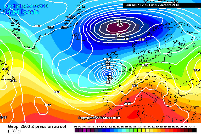
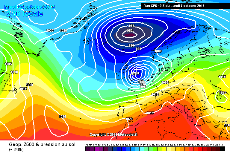
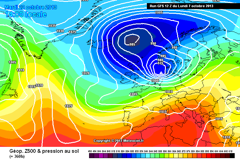
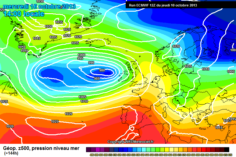
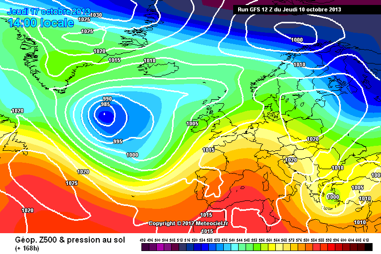
Ok a little better from the ECMWF 12z run tonight, Sw'er flow advancing to the western shores of Eire by Wednesday, with the low pressure centre a good bit further east when compared to yesterdays 12z run for the same time frame.
Still the model analysis having issues resolving the secondary centre forming on the primarys' western flank, as you can see from the next slide the primary ahas jumped backed west merging with the secondary, Ideally we could do with the primary pushing further east for Thursday / Friday, or the secondary getting a slingshot around the primary southern flank hitiing the UK Thursday and Friday.

Still much to be resolved yet. The GFS 12z is arse tonight 
@ +168hrs
| |
|
by Howard Rowson
>>
11-10-2013 06:46:57 | |
The UKMO taking the reigns for next week. The 00z run model dialing in the Sw'er for Thursday, perhaps as early as Wedesday pm. As next wek draws closer we are tending to see improvements especially towards midweek and on, nothing to really shout about until then as the current synopsis stands. That aside given the current setup is does n't take too much variation from that forecast for some wind to be dialed in on a day to day basis. ie location of weather fronts, variations in pessure differentials and proximity of near by low pressure systems ie. the ie the 1000mb system sat over se england Monday 2am, if that develops slightly further north and a notch or two deeper a strong sw'er may develop through Sunday pm. Plenty to keep an eye on on a day to day basis.
Thursdays' evolution of the system out west pushing east, a Sw'er not quite a gale but winds should be strong up the e-channel
.
| |
|
by Howard Rowson
>>
11-10-2013 06:49:17 | |
apologies for the early morning typos and repetitions 
| |
|
by Howard Rowson
>>
11-10-2013 12:44:58 | |
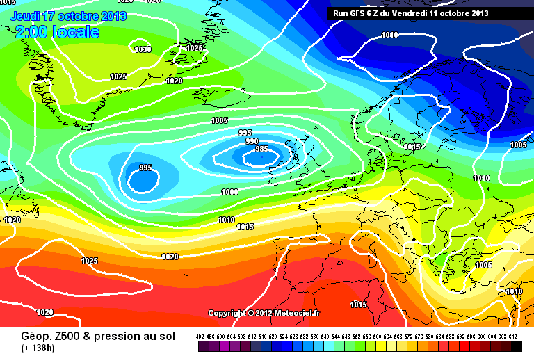
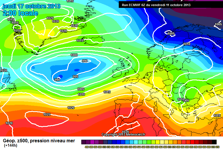
Ok ... the GFS 06z model now aligning with the UKMO model ... ECWMF aligned after a fashion.
GFS 06z for Thurday 2am. (+138hrs)
UKMO 00z run for Thursday 2am (+144hrs)
and the ECMWF 00z run for Thursday 2am (+144hrs)
| |
|
by Howard Rowson
>>
11-10-2013 12:48:22 | |
oops GFS and UKMO look identical above .... lol I re-pasted the GFS instead of the UKMO ..
Here's the UKMO
| |
|
by Howard Rowson
>>
21-10-2013 06:54:42 | |
The general trend for the UK over the next couple of weeks is one of increasingly unsettled conditions with a heighted "risk" of gale force winds associated with storm systems tracking west to east across the north atlantic ..especially next week,
| |
|
by Howard Rowson
>>
22-10-2013 17:41:53 | |
Bit of a westerly for WK tomorrow circa F5-F7 , high water around 1400'ish @ 8.6m therefore no breach expected. Veer to west soon after first light 9am 'ish. MetO have big Monday on the horizon with 960mb tracking east across Scotland classic Sw veeing West .. one to keep an eye on as the week progresses. Thereafter we go zonal  with deep low pressure systems forming up stream and tracking east with deep low pressure systems forming up stream and tracking east
| |
|
by Howard Rowson
>>
22-10-2013 18:07:19 | |
MetO potential big Monday, some way off yet, but the atlantic appears to be firing up. thats a 955mb storm system pretty deep./

| |
|
by Howard Rowson
>>
22-10-2013 18:35:25 | |
ECMWF has a slightly different view to the Mets.

| |
|
by Howard Rowson
>>
23-10-2013 06:30:59 | |
A slight increase in the westerly flow for WK today, peaking 30kts gusts to 35kts mid morning, before returning back to F5-F7.
| |
|
by Howard Rowson
>>
23-10-2013 06:47:19 | |
A little tricky at present to interpret how the storms systems out west will track in Sunday through Tuesday, secondary inswinging systems now key to the flow strength and direction. Both ecmwf and MetO have a system developing sunday iut west in the primary circulation, possibly hammering in to the south of the UK monday into tuesday. GFS picks up on this theme too, but the system a little further north, hence the west 7-9 for wk monday mid morning (xc)
That aside for the mo . WK should be pretty good today in particular during the mid morning, when the flow may gust to g-force.
| |
|
by Howard Rowson
>>
23-10-2013 06:49:22 | |
NAE for 0900hrs not sure if thats' gmt or BST

| |
|
by Howard Rowson
>>
23-10-2013 19:25:36 | |
Monday is goning to be one interesting day widn wise ..... where is the F10 bomb heading is the big question from a track and depth perspective./MetO and ECMWF pretty consistemt with their synopsis, GFS has the rapidly deepening storm system a good bit further south.
MetO eye candy chart: Anywhere 200miles south of the centre in for an F8-F10 pasting.

| |
|
by Adam Gustafsson
>>
23-10-2013 19:46:11 | |
Hi Howard
The charts have been changing like hell over the last day or so!! Hopefully something will come to fruition over the next day or so since I'm now on HOLIDAY!!!!
Very excited too! At the moment looks as though the low will zip over quick on monday.. Sunday looking pretty windy though!
Tides at St Johns/Daymer are sadly poor but tides at Portland or WK look good
|  |
|
by Howard Rowson
>>
23-10-2013 20:25:17 | |
Hi Adam, good to see the potential for some big wind timing with school hols ... makes a change mate! This one will go to the wire, hardest systems to track these rapdily deepening secondaries, relying wholly on the jet stream for final depth and track, it actually has a similar make up of euro storm Kyrill, Jan 18th 2007, winds peaking at Wk circa 80kts, thanks to the formation of a stingjet. The Ray could be prime spot for the UK Monday, lowtide around 1330. One to keep a close eye on for sure.... Holland watch out! That looks like hurricane force F12 Sw'er to me.
| |
|
by Howard Rowson
>>
24-10-2013 06:47:31 | |
Still very much an open book with regards to Mondays' storm track and depth... At present there is a risk of a swathe of storm force winds on the southern flank as the storm system is expected to deepen rapidly as it approaches the UK late Sunday into Monday. As Adam states above the forecast (wind) at present is all over the place, as the models are trying to resolve the track and intensity of said incoming system. There is a bias to a more southern track of the storm, possibly up the channel, delivering the swathe of F10 across northern France, Belgium and potentially up into Holland. Alternatively , the middle ground sees the system tracking east across southern england, or still, a solution slightly further north may transpire .... much to be resolved yet.
| |
|
by Howard Rowson
>>
24-10-2013 18:04:09 | |
Ok MetOffice servere wind warnings came into force today, amber covering the south coast, yellow M4 north to Brmingham.
Both UKMO and GFS models have the storm system tracking ENE north of the M4, leaving the southcoast primed on the southern flank for a Sw'er veering wsw then west F7-F9 with gusts, well in access of F10. Both Portland and Southend look to be going off rather nicely, perhaps , dare I say it , too much wind. Timing, track and depth still open to change. The flow kicking in Sunday from the primary system to the west of Scotland before the secondary swings in, late Sunday / early Monday, central pressure dropping like a stone "the bomb". Holland, Germany Denmark in the line of fire soon after.
| |
|
by Howard Rowson
>>
24-10-2013 18:17:51 | |
Positive output from the ECMWF 12z keeping the storm track further north, helping to diminish the threat of a more southern track up the channel.

| |
|
by Howard Rowson
>>
24-10-2013 18:51:54 | |
Looking a little further ahead, if WK missed out Monday, upstream developments looking favourable for another shot later in the week. (ECMWF)


| |
|
by Howard Rowson
>>
24-10-2013 19:40:04 | |
Eplosive Cyclogenesis Explained:
1987, 1997 , 2007 ... 2013?  A good read :- A good read :-
http://www.eots.co.uk/reports/bomb/bomb01.htm
| |
|
by Howard Rowson
>>
25-10-2013 06:58:56 | |
Useful information from the UKMO
http://www.metoffice.gov.uk/news/releases/archive/2013/Severe-storm-risk
| |
|
by Howard Rowson
>>
25-10-2013 07:12:22 | |
The Storm is forecast to drop 30mB in 24hrs (2am Sunday to 2am Monday.. therefore achieves "Bomb" status. It's going to track ene across the uk so fast that the time increments of the models are not of a sufficient time window to track exactly how it will cross the UK. Going off the wind stats then , peak flow is expected early monday morning before day break from the SSW, wind veering WSW through the morning and maintaing F7-F9 flow veering westerly later Monday.
GFS has decided not to bomb this storm now running a small wave depression across the south of the UK around 985mB with a significant weakened flow.
WK still a possibility.
Strong to gale SW'er for Sunday arvo. amd potentially a west to wnw Monday 6-8 for a time, stillvery much open to debate, based on the final track and depth of the "Bomb"
| |
|
by John Roberts
>>
26-10-2013 09:44:58 | |
Forecast has made the front page of some of the papers this morning. Time for some big home grown speeds?
Finally holidays, wind strength and direction are all perfect for me.
Oh no!...... Wait! ..............We have a 4 week old sprog in the house again.....Guess I will be enjoying it vicariously via the postings here.
One day the planets will all be inline...
|  |
|
by Howard Rowson
>>
26-10-2013 14:26:45 | |
Congrats John great news on the expansion of the Roberts clan You would n't happen to have a speed board for sail then mate? possibly a Naish SP60?
Ok,,,a wish the Meto would produce a 1hr increment forecast pressure chart, so we could see a more detailed view of the incoming stormtrack and depth, rather than the 6hr increment. Nonetheless the 3hr increment wind data will more than suffice.
Yesterday day the Met increased the northern edge of the amber warning zone, and implemented a yellow warning for northwales and as far north as north west england.
The current forecast track iacross the UK is circa sw wales to Humberside, thus all of southern england from B'ham south will be on the southern flank of the storm and consequently the strongest of the flow,
The flow will peak early monday morning on the south coast before day break transferring east to kent mid morning to noon. The strength of the flow is arbitary 'kin windy. solid F9-F11 with gusts on exposed coasts estimated at 80kts+, This is during the peak flow which will be transferring east along the south coast as the storm deepens and tracks ne across the UK, Post initial peak the flow should moderate (used loosely) to F8 to F10 SW-WSW with a further veer to West and easing F7-F9 for the afternoon.
Portland's wind will peak before day break F9-F11 moderating to F7-F9 during the morning sw/wsw perhaps veering west late morning into the afternoon, wind gradually easing F6-F8.
Southend's wind again looks to peak around day break F8-F10. During the lowtide window (an estimated 2-3 hrs eaither side of the 1330 lowtide the sailable flow should be WSW F7-F9.
West Kirby, Sunday afternoon sees a respectable F6-F8 from the sw or wsw and sunshine, clear air of wales should ensure a good but gusty flow. Now Monday, and the hardest call to make, as we a reliant on the forecast handling the storms sw-ne uk transit / track and depth pretty much spot on for the forecast F6-F8 Westerly to kick in, as the storm tracks into the north sea, a late call required on WK then.
Holland. The flow will be building through the early hours of Monday from the south / ssw. A couple of weather fronts (cold then occluded) to track east through the morning will driving rain and violent winds F9-F11 from the SW, by noon. The afternoon should be SW or thereabouts F8-F10 with the wind perhaps veering closer to wsw and modering F7-F9 as the afternoon progresses.
So in summary, (and updates to follow)
The UK South Coast spots - South veering sw/wsw and then west F9-F11 easing F8-10 then F7-F9 , F6-F8 later monday.
West Kirby, potentially F6-F8 from somewhere between wsw and wnw perhaps initially NW as the storm's centre tracks across the area.
Belgium > Holland > Germany > Denmark. The storm is expected to track across the north sea Monday afternoon and continue its north easretly track to the north of Denmark Monday evening / night. Winds will be initially from the south early monday veering sw/wsw by noon, exceptionally windy F10+ . It is most likely that the flow will not reach West by stay somewhere betweem sw and wsw for day light hours monday afternoon.
| |
|
by Howard Rowson
>>
26-10-2013 15:12:27 | |
Correction:
We loose BST tonight making Mondays' Southend lowtide approx 1230hrs. an hour early than stated above.
Hurricane Force (F12) winds may well batter into coastal regions of sea areas Fisher, German Bight, Humber Monday late morning / midday into the afternoon
| |
|
by David Willows
>>
26-10-2013 19:22:28 | |
Hi, since this is a UK thread, i'd thought i'd ask if anyones planning on going to the ray on monday for the 40-70mph wind? tides right and possibly some sunshine, a 1/10 yr storm (for the SE), i presume the seafront carpark will be full haha!
|  |
|
by Howard Rowson
>>
26-10-2013 19:43:17 | |
Hi David, checkout Mike George's Speed Series post under UK Speedsurfing on Facebook, it is most likely Southend will be firing monday and therefore the first round of the speed series for those who wish to take part.
| |
|
by Howard Rowson
>>
26-10-2013 19:46:26 | |
Here's a link to the FB UK Speed Sailing Page,
cheers
H
https://www.facebook.com/#!/groups/378944492224994/?hc_location=stream
| |
|
by Michael George
>>
26-10-2013 21:17:53 | |
| We're all monitoring the forecasts closely.
Tomorrow has already been announced and could be a counting round with enough attendees and potential for 40 knot averages.
Monday is hard to call at the moment. Could be epic or could be unsailable!
Seems to me that the best time is likely to be as the wind starts to reduce. 40 knot gusts are plenty for the Ray. |  |
|
by Howard Rowson
>>
27-10-2013 11:04:33 | |
11th hour call for monday, overnight mods pushing the storm through rather quickly with the strongest of the flow before daybreak, leaving the south coast in its wake for Monday, wind moderating soon after the intense burst. Best of the daytime flow out over the north sea and into northern Holland around noon and east thereafter/
Southend may catch the tail end during mid morning. West along the south coast soon moderating from F9-F11 to F6-F8 then F5-F7 wsw or west. pretty much blowing itself out by noon.
Wk still has some potential for West 6-8 for the morning, backing wsw pm and easing 5-7
We shall see how the 12z run data stacks up later this arvo.
| |
|
by Michael George
>>
28-10-2013 08:59:02 | |
Yesterday was fun. 40mph gusts felt the perfect strength and with a little more west the east course would be unbelievably fast!
The winds seem to be easing rapidly so it'll be interesting to see whether we'd have had another crack at the Ray this morning.
I'm in the office so I'm hoping that we've made the right call.
| |
|
by Mark Ingram
>>
28-10-2013 12:37:52 | |
Hi Howard,
How is WK looking for Tuesday. Does it look like the wind will strengthen compared with today?
|  |
|
by Howard Rowson
>>
28-10-2013 13:26:38 | |
@ Mike ... I think you made the right call mate. Congrats on yesterdays pb btw a job well done. South coast as forecast got a real pounding winds peaked at the needles IOW 99mph through the early hours, the storm as expected whistled through pretty quick, although the westerly wake is still galeforce on the south coast. Looking at the mid range plenty of wind on the horizon.
@ Mark.... West 6-8 is still the forecast mate. The wind has been up at 6-8 earlier this morning but tending to back wsw an eased 5-7 before once again veering west later and back up to 6-8 through the night perhaps wnw or slighly broader. The flow should be back to w-wnw for the remainder of the day circa f6-f8 from first light to late afternoon, before easing somewhat and backing Sw Tuesday evening and overnight into Wednesday. (Nae Model data)
Nae 9am Tuesday  WbN 25-30kts gusts to 40kts WbN 25-30kts gusts to 40kts

| |
|
by Howard Rowson
>>
28-10-2013 13:30:26 | |
Looking forward to seeing whar happens a Vollierwiek this arvo currently WSW @ F9-F11
| |
|
by Howard Rowson
>>
30-10-2013 11:53:14 | |
Two storm systems to deal with Friday and through the weekend, potentially giving rise to galeforce winds again. The storm tracking across the UK late Saturday into Sunday may give rise to a westerly flow for WK Sunday circa 6-8.
NB @ WK
We may have to check with the owners of the weatherstation in the car park, as I was keeping an eye on it all yesterday and the Wirralcam. Skylink reporting the angle for the majority of the day was between 288 and 292 just shy of wnw with a 26kt mean average wind speed with peak mean avg @ 27kts. I would expect the wind at weathersation height to be a little stronger than over the course, but the angle should be close to the wind over the wall.... it may not be calibrated and set up for true north. I have a similar unit at home and have to adjust it now and again expecially when its had a batterling 
| |
|
by Howard Rowson
>>
1-11-2013 10:24:31 | |
At present the storm system forecast to track across the UK Saturday into Sunday looks like it will deliver the big west to wnw'ly through the early hours of Sunday, 6-8 peaking 7-9, leaving WK in 5-7 westerly wake for Sunday. First light Sunday may still be in the galeforce swathe. One to keep an eye on through today and tomorrow. November looking unsettled and windy for the next week or so with deep low pressure systems tracking east to the north of Scotland and high pressure to the sw / s / se, tending to favour a south westerly flow perhaps wsw , galeforce at times.
| |
|
by Howard Rowson
>>
1-11-2013 22:23:04 | |
Big winds for WK kicking in from the west Saturday evening through Saturday night F7-F9, a chance of the residual flow being up around 6-8 from the west Sunday dawn to high tide breach before 10am. Post breach around 11'ish F5-F7 for a while, wind moderating through Sunday and backing to the SW.
Southend potentially good for a while on the run up to the low tide at 17:40 Saturday, SSW F5-F7, and again dawn Sunday until the sand bar gets covered on the run up to the noon hightide west or wsw possibly 6-8.
Portland's big sw'er kicking in for Saturday afternoon veering west after dark circa f7-f9. West 6-8 for Sunday, backing wsw on the run up to dusk.
| |
|
by Howard Rowson
>>
2-11-2013 10:11:54 | |
If only:

Shame the epic flow peaks at midnight tonight. (40-50kts) Nonetheless current forecast indicating the residual West to WNW flow should still be up at 6-8 first light until noon, again the 10am 9.1 high tide not helping with a breach from 9:30 to 10:30 (estimated). Once the HT clears the wall the flow should still be good, hopefully still up at 5-7 slowly easing off late morning through the afternoon to sub F5 by 1500hrs.
Yes it is November , as the next couple of weeks are looking zonal with plenty of deep lp systens tracking east, a new Stormtrack topic will commence Monday
| |
|
by Howard Rowson
>>
2-11-2013 12:36:28 | |
Current weather stats indicate a SSW for WK imminent circa 6-8 for the afternoon now the cold front has paased through, excellent broad on port potential
| |
|
by Howard Rowson
>>
2-11-2013 12:39:07 | |
Wk lake cam now showing the wind kicked in - SSW F6+
| |
|
by Howard Rowson
>>
2-11-2013 12:42:13 | |
NAE 06z update looking good for tomorrow morning mean average @ first light F7 easing to F6 by noon ( thats mean average , + 2 BFT for adding in the gust factor), 0900 is the wrong chart .. lol
| |
|
by Howard Rowson
>>
2-11-2013 13:09:56 | |
It's quite a rarity to get a SSW flow behind a cold front at WK especially 6-8. Ckear air behind the cold albeit peppered with beefy squalls gives a good chance of a decent flow. Skylink back to SSW and F7
| |
|
by Howard Rowson
>>
4-11-2013 12:51:53 | |
The forecast not playing ball with WK at present, forecasts not exactly verifying ... another opportunity tomorrow afternoon with the NW'er late morning backing WNW to West. F5-F7 probably about right err'ing on the cautious side. Given the data on the NAE model 12 noon looking too broad nw'er, 1500hrs looking just North of West, mean average wind speed for the arvo .. F6 therefore circa F5-F7 lakeside.
| |
|
by Howard Rowson
>>
4-11-2013 13:13:05 | |
Suffice to say the MetO have the flow kicking in at 0900 due west 27mph gusting 40mph, borderline 6-8 until 1500 when the flow eases to 5-7. West 5-7 is the inshore waters forecast for GOH to MOG. Tuesdays' highwater for Hilbre is 11:41 @ 9.41m, therefore probably only sailable after the ht clears off the wall early afternoon.
| |